Thoughts & Opinions About Trends, Technologies And Economic Advances In Smart Cities Evolution.
NJ Utility Deploys Augmented Reality To Support Field Utility Work
Toms River Municipal Utilities Authority (TRMUA) Foresaw A Day When AR Technology Would Allow Field-workers To “See Through The Ground”, And View The Utilities Beneath Their Feet Without Having To Rely On Vehicle-mounted Rugged Laptops.
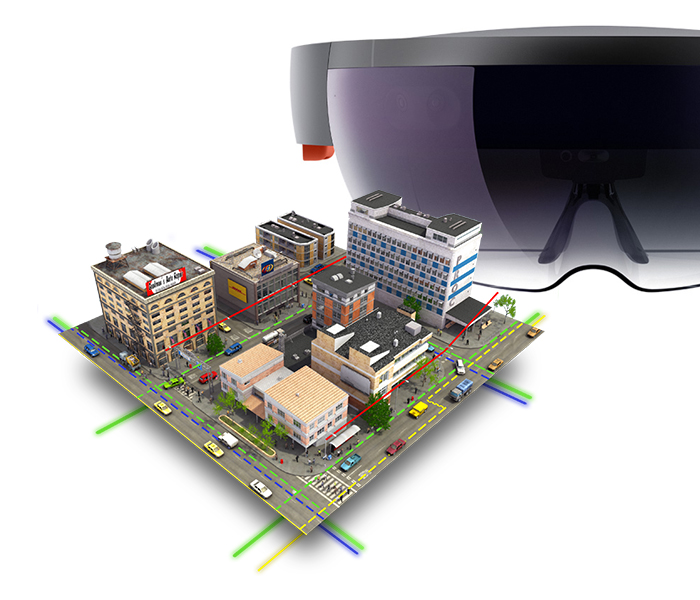
Augmented reality works by merging the physical world with computer-generated objects, allowing a field technician to have a consolidated view of the physical workspace overlaid with virtual equipment and line identifiers.
TRMUA maintains 435 miles of underground utility lines, 18 pump stations, and serves 47,000 ratepayers covering an area of 55 square miles in Toms River, NJ (population 92,000).
TRMUA had already built a robust geographic information system (GIS) using ESRI’s ArcGIS online services. The utility infrastructure maps and supporting data were accessible in the field on laptops. The utility was ready to take the existing GIS to another level of dynamic mapping and data retrieval. He wanted field technicians to be able to “see” objects that are normally concealed: wires cutting through treetops, cables situated behind natural and artificial obstacles, underground piping. This new level of awareness held the promise of reduced work times, improved safety, and greater accuracy of field data. The ability to work hands-free would further magnify the benefits of such a system.
With the data infrastructure in place, attention turned to the user experience of the field technicians—how the wealth of data could be better managed with a combination of hardware and software to deliver an intuitive interface, one that took advantage of new presentation technologies such as virtual reality and augmented reality. Mixed reality was the perfect environment for allowing his fieldworkers to see concealed utilities while remaining situationally aware of their actual surroundings. TRMUA selected Toronto based Meemim vGIS as its platform of choice to enable the technology integration between ESRI’s ArcGIS, Microsoft Azure and Holo Lens. Meemim specializes in meeting technology needs of municipalities and utility companies.
New Zealand Transportation Agency Uses Smart Vehicle-Speed Modeling To Save Lives On Rural Roads
NZTA, The Organization Responsible For Delivering A Safe And Efficient National Transportation Infrastructure System In New Zealand, Set Out To Develop A Spatial Road Safety Risk Assessment Methodology That Specifically Targets Low-Volume Rural Roads.

High-risk curves on mountainous roads can be easier for drivers to manage when they have adequate signage and barriers.
When it comes to investing in road safety—a primary concern for all governments—the focus is to identify and prioritize projects that will save the most lives and prevent as many serious injuries as possible. Road managers are already using geospatial analysis to identify high-risk roads and prioritize safety projects.
The agency wanted to be able to evaluate the safety of horizontal curves—those gradual turns that connect two adjoining strips of highway—based on a road’s geometric and operating speed features.
NZTA had two key requirements for the risk assessment methodology.
1. It needed to be created using already-available knowledge of the road network, including existing spatial data and associated transport attributes, such as speed limits. 2. It had to be cost-effective so it could be readily applied across an extensive road network.
NZTA’s geospatial risk prediction methodology was based on a road engineering process that includes driver behavior models for acceleration on straight roads and deceleration on curves along high-speed corridors. The risk assessment process involves comparing approach speeds with the radius, or tightness, of a curve to assign a risk classification to each curve in both directions of travel. This risk classification is a proxy for the likelihood that a driver will lose control while taking the curve.
OSLO Plans To Turn Its Vehicles Into Data-Generating Mobile Sensor Platforms.
The City Of Oslo Is Targeting New Triangulation Possibilities With Customers, Vendors And Other Users – And A New Coexistence Based On Data Sharing. | Its Oslo’s Version Of “Bus-as-a-Service”.
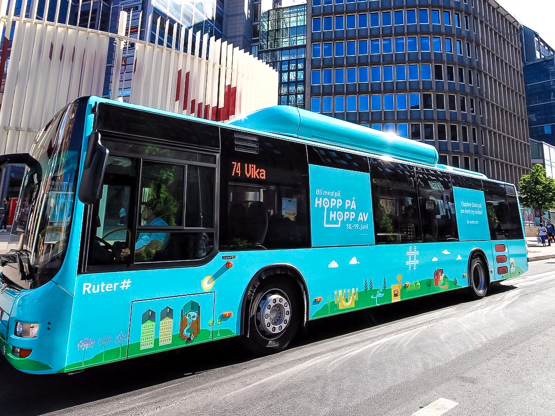 Smart cities need lots of data for planning, decision-making and new services. Mass-transit vehicles are everywhere in the city, so using them to provide real-time data for these applications makes obvious sense.
It’s not only aiming to build a more efficient and flexible IT system for operating its buses, but it also wants to provide the Norwegian capital with data for new smart-city applications and services. Oslo’s buses currently have seven separate and proprietary systems on board, to support live data for several functions, including ticketing, passenger information, position reporting to the control center, and providing technical maintenance data to the bus operators. These systems didn’t interoperate and, in some instances, they even need separate radio communications for their respective uses. The objective going forward is to have buses carry an open and standards-based IT platform with interfaces and protocols that all vendors will have to support. Doing so allows all data from the entire transport fleet to go out into the public space. The result will be an easier systems-integration environment, where subsystems will be able to share resources such as GPS and radio communications, as well as their data where applicable.
Data from all environmental sensors on board the bus, like traffic speed, light, noise, pollution among others, will in principle be publicly available.
City Of Mumbai Leverages Bio-Mining For The World's Largest Municipal Waste Remediation Project
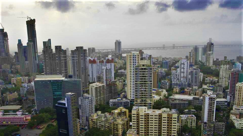
More than 127,000 tons of solid waste is generated every day in India. Much of this is unauthorized trash dumping by individuals and a larger part by small businesses, To deal with the country’s chronic trash problem, many cities are asking their own citizens to become whistle blowers.
The City of Mumbai generates 7,100 tons of waste a day, which is dumped at three grounds within the city.
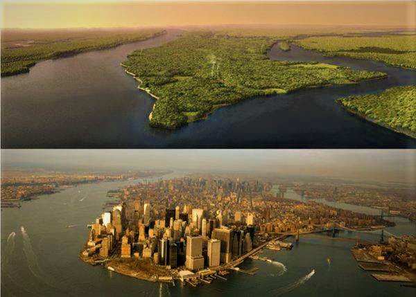
BEFORE IT WAS NEW YORK: How Henry Hudson May Have Viewed Manhattan in 1609.
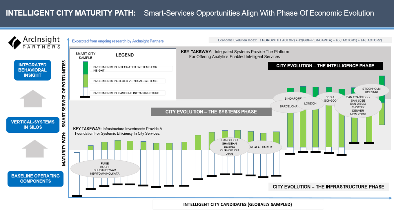
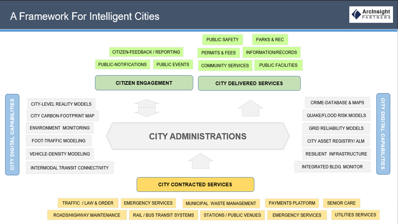
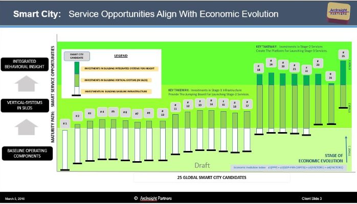
INTELLIGENT CITY: A Framework For Intelligent Value Creation
This Intelligent City Framework (initially published on LinkedIn) was excerpted from a comprehensive global study of smart city strategies by ArcInsight Research Partners (currently inflight). The first part of this research paper reflects the group’s findings so far, and incorporates insights shared by numerous industry practitioners, strategy-thinkers, and IIoT experts.
THE IMPERATIVE FOR CITIES TO BECOME INTELLIGENT TODAY
Mega-countries Have Emerged: China has the largest urban population (758 million), followed by India (410 million). These two countries account for 30 per cent of the world’s urban population and, with another five countries, the United States of America (263 million), Brazil (173 million), Indonesia (134 million), Japan (118 million) and the Russian Federation (105 million), account for more than half of the world’s urban population.
Megacities Are Emerging (cities with population of 10 Million or more) : In 1990 there were 10 megacities cities and home to 153 million people, representing less than 7 % of the global urban population. Today, the number has nearly tripled to 28, the population they contain has grown to 453 Million, and account for 12 % of the world’s urban dwellers.
The New York metropolitan area became the world’s first megacity in 1950, with a population of 10 million people or more.
On the other side, more than 275 million people will move into India’s teeming cities over the next two decades.
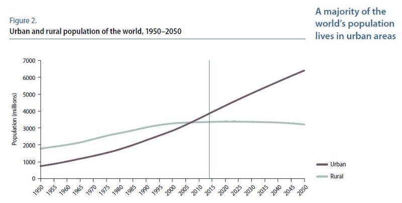
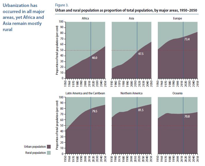
Half of the world’s population currently live in cities. This number likely to reach 70% by 2050. Actions are required to ensure the demands of stretched infrastructure, services and resources can be met effectively.
By 2050, planners predict there will be 40 megacities around the world. In terms of economic might, these forty city-regions may be responsible for over two-thirds of the total world economy and most of its innovation. To fuel further growth, an estimated $53 Trillion will be invested in urban infrastructure in the coming two decades.
Three kinds of cities are driving the new urban topology: global hubs, mega-cities, and gateway cities. While these categories are fluid and sometimes overlapping, each has unique attributes and roles in a city-dominated world.
Global Hubs are also global capitals, the top nodes of the world economy into and out of which much of the world’s wealth and talent flows. They are household names around the world: New York, London, Hong Kong and Tokyo, etc.
Mega-Cities are the hugely populous magnets not just in their countries but sometimes for entire regions: São Paulo, Lagos, Cairo, Istanbul, Mumbai, Jakarta, and others.
Gateway Cities are a crucial new layer of urban development in a fast-growing world. They are regional clusters that facilitate access to frontier markets. Such cities include Cape Town, Dubai, Tripoli, Almaty, and Kuala Lumpur. Gateway cities are competing most fiercely to brand themselves as emerging hubs.
Having painted a bleak outlook, we must ensure not to lose sight of the fact that sooner (than later) global developments (economic / demographic / aspirational) will drive us to invest in Smart Cities. One hopes the drivers will have more socio-economic urgency, than merely aspirational.
 Within the next three years, one-third of medium- to large-size cities will “define their City Roadmap leveraging third-party maturity models and best practice studies.” Economic growth and livability also are high on the list. IDC forecasts that through 2018, 90% of smart city action plans will concentrate on supporting socio-economic efforts to reduce economic divisions, increase domestic industry and the number of skilled workers. Within the same time frame, 75% of state and local organizations will draw on citizen data generated from external sources and use it for transportation management and real-time crime centers — although they will be challenged with the task of converting data from a variety of sources and formats into information they can use quickly and effectively.
WHAT IS AN INTELLIGENT CITY ? The Noise & The Perceptions.
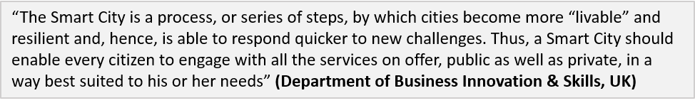
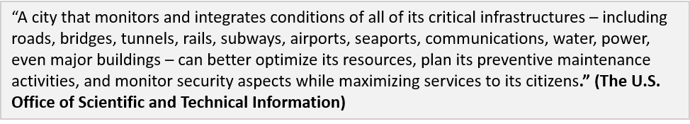
The sad response is, there is no universally accepted definition of a Smart City. It means different things to different people. The conceptualization of smart city planning, therefore, must vary from city to city and country to country depending on, the level of development, willingness to change and reform, available resources and aspirations of its city residents. A smart city should have a different connotation for Bangalore than, say a city such as Berlin.
An Idealized Descripton: An Intelligent City includes an integrated e-governance system along with infrastructure (transport, parking, traffic management, power, water, safety and security) management and citizens’ services.
- Pervasive sensors enable cities to collect measurement data about energy, water, transportation, and buildings systems in real-time. Low-cost communications and new communications protocols greatly simplify and reduce the cost of gathering data collected by sensors. Protocols such as Zigbee® and Bluetooth®, growth in Machine-to-Machine (M2M) networks, as well as continued improvement in wireless and wire line communications technologies, enable cities to affordably collect data from widely distributed networks of sensors.
- Real-time management systems automate the control of infrastructure systems, improving the efficiency of infrastructure by optimizing performance. Advanced analytics make use of the large amount of raw data collected and translate it into actionable intelligence, which a city can use to improve the performance of infrastructure
Looking at initiatives underway around the world, a more apt description may well appear thus. An Intelligent City is a set of disjointed vertical systems (or system-of-systems) implemented to deliver a narrow set of civic services.
Neither definition serves to complete our understanding of a smart city strategy any better. And if you believe things get easier, here are five more definitions reminiscent of the five blind men trying to describe a big elephant. The elephant being the conception of a smart-city itself. The five men are not exactly blind but highly competent entities. They simply visualize a smart-city through their own opportunistic blinders.
The Public Service perspective:
The Efficiency perspective:
The Urban Design perspective:
The Higher-Good perspective:
The Technology perspective:
A fellow researcher shared some interesting and important thoughts recently. “The challenge with attempting such a broad synthesis within a succinct definition is that you end up with a very high-level, conceptual definition – one that might be intellectually true, but that does a very poor job of explaining to the wider world what an Inteligent City is, and why it’s important. We need a simple, concise definition of Smart Cities that ordinary people can identify with. To create it, we need to reclaim the “Smart” concept from technologies such as analytics, the Internet of Things and Big Data, and return to its original meaning – using the increasingly ubiquitous and accessible communications technology enabled by the internet to give people more control over their own lives, businesses and communities.”
Also, because of multiple perspectives about the concept, many Smart City discussions quickly gravitate towards arguments between opposing camps (as opposed to constructive ideas): infrastructure versus people; top-down versus bottom-up; technology versus urban design; proprietary technology versus open source; public service improvements versus the enablement of open innovation
The consequence of this lack of cohesion and focus is that very little real money is being invested in Smart Cities to create outcomes that cities, towns, regions and whole countries have set out for themselves in thousands of Smart City visions and strategies.
CHARACTERISTICS OF AN INTELLIGENT CITY
The Rational Test: That incremental value is generated from two sources (a) Integration and (b) Insight. Everything else is mere city development projects.
Integration ensures control information generated by one vertically-focused system can identify and combine, with that generated by another similar system serving a different control function. Insight occurs when the combined data sources are cleansed, organized and run through algorithmic processes to generate patterns (consumption, behavioral, of events, and of motion).
Intelligent Cities Feature Sustainable Urbanism With An Adaptive Capacity For Resilience. By Design. (A Rational Definition)
- Aspire Towards A New Paradigm Of Urban Mobility: The serious congestion on public roads cannot be solved by looking at the problem from the same paradigm of the previous century. Ownership Vs Usage; Autonomous Transportation; Drive Commute Vs Telecommuting; Physical Presence Vs Telepresence (or even better, A Digital Twin). New emerging paradigms such as the Sharing-Economy are critical to delivering the same familiar services without the assumed underlying infrastructure. projects from bike sharing to intelligent parking to green municipal cars
- An Intelligent City Sets A High Bar For Energy Efficiency: everything that relates to energy management, from municipal efficiency to individual citizens monitoring their own usage.
- Senseable & Integrated: The beauty of a Smart City is that it is an integrated ‘sense, analyse, control and data log’ system that encompasses every citizen, infrastructure, resource, geography and past data.
- Enables Social Collaboration For Urban Resiliency: Ensures meaningful stakeholder engagement. Resiliency is really the inverse of risk, it is fundamentally about maintaining an acceptable level of service and livability in a dynamic and changing environment. How does a flood or tornado affected community regroup quickly and organize itself using social and collaborative technologies before public services can kick-in with support.
- Leverages Open Data, Open APIs, Open Standards: How transparent is governance and city management data to its public stakeholders. How does the public consume open data and create new valuable services for themselves and the city using innovative analytics.
- Has Adaptive Capacity Planned-In: whether or not there’s redundancy in the system.
- Leverages Digital Technologies: “We have a lot of accelerators, co-working spaces, incubators, working in the space of digital, and have some accelerators and hackathons around smart cities, things like putting people, young people, or students, or entrepreneurs, developing new apps for the city around the smart city and everything that goes with digital.”
- Accelerates Co-Creation & Participation: Creating new value out of data made available freely to the public. “We have a participatory budget because we believe that one of the key cornerstones of a smart city strategy is participation and co-creation. ”
Do Intelligent City Design-Templates Matter: Let’s illustrate the design challenge with three data points. Singapore and Dubai were cities created by design from a well-defined blueprint. Both these cities went from a nondescript desert town and a sleepy backwater to one of the most developed cities in the world, all in a space of 50-odd years. Both great candidates to be smart cities.
Contrast this with the city of London which has a 1000-year recorded history of continuous habitation and use. There is Mumbai, a city with a history not quite as long, but on an entirely unique economic path. One could in a short 5 year period turn a city like Dubai towards autonomous transportation without too many challenges (try doing the same in a city such as Mumbai). Interestingly while both could benefit immensely from autonomous transportation, strategies to implement this smart city component must take widely divergent tactical paths.
All three candidate cities are moving headlong into the future at a pace unimaginable 50 years ago, and (for good, or for bad) will be unable to reverse time nor slow their economic course of growth, given how tightly integrated they are with global economic systems, and their accepted designation as “too-important-to-fail” economies from a systemic standpoint.
A universal design-template/paradigm/ does not lend itself to replication around the world without close evaluation of contextual realities within which cities are evolving.
Intelligent Cities Set Divergent Goals To Align Local Economic Priorities Smart cities need not be thought of as cities of the future. They can be the cities of the present. By the end of the current decade, many technologies critical to a smart city, including monitoring and sensor technologies, intelligent traffic systems, and energy management systems for buildings, will be deployed on every continent. And while no single solution defines a smart city, the technologies being put in place today are pieces of the smart city puzzle. The easiest implementation of a Smart Cities project is one of a city that doesn’t exist. To build-in state-of-the art systems, processes, governance and technology at the core of a city in the process of being created is probably an ideal use-case of a smart city strategy, and certainly a rare opportunity for city planners. (We will examine several examples of such opportunities in Part-2 of this research article.)
However, the more likely situation is one of a city that has evolved over a hundred (or hundreds of) years with a mix of tradition and modern systems, has hundreds of thousands/millions of residents actively inhabiting it and an economy doing just fine. Considering a rip-and-replace strategy is practically unimaginable here.
Mature economies in Western Europe, the United States, and Japan see similar opportunities, but in many cases different challenges. These regions boast highly engaged citizens, sophisticated and multi-layered government, and deep access to investment and technology innovation. Yet their decades-old systems are aging and deteriorating, rarely sharing information, and often operating under the responsibility of different departments or public jurisdictions.
As an example, the European Union (through the European Smart Cities and Communities Initiative) has targeted emissions reductions in cities as critical to its goal of reducing overall energy use by 20% by 2020, and to the development of a low carbon economy by 2050. A perspective from one such smart city candidate makes the point very effectively.
On the other hand. Emerging economies (India, China and Brazil) have immediate needs to develop newer cities smart. Their exponentially growing populations have the most pressing short term needs, including flood preparedness, prevention of blackouts, traffic congestion, crowding, and logistical difficulties which accompany fast-paced (often unplanned) urbanization.
A FRAMEWORK FOR INTELLIGENT VALUE CREATION

Mapping The Strategic Context : There is no such thing as a universal design for Smart Cities. To be clear, there is not a single example of a smart city in existence today. ZERO. Just Not Yet. What exists today is merely a disjointed set of technology enabled vertical systems (or a system of systems, at best) that partially address one or more city priority or two on a standalone basis. We are nowhere close to the aspirational goals a smart city purports to deliver.

Stakeholders (Nation, Smart City Aspirant & Citizens) Must Examine Some Key Questions:
- Visioning: How does an increasingly multi-ethnic society operate ? What is the city’s stage of evolution & economic development ? What are its key macro priorities: short term / long term? What is an appropriate planning model for our smart city – “Top-Down” or “Bottom-Up”? What is our blueprint for a smart city. What outcomes indicate achievement of our Smart City goals. Where does accountability lie for achieving the overall vision?. The short-term project goals ?. What is the critical factor driving need for autonomous vehicle for your city (orderly transportation, traffic delays, congestion, air-pollution ? Have the city-planners considered/planned/budgeted for key infrastructure pieces needed to enable autonomous vehicles.
- Executing: What implementations (of vertical/horizontal systems) qualify as baseline for a smart city project ? How does one define benchmarks and evaluate success-criteria. What metrics serve as reliable tests for achieving smart city objectives. How does a city assess it unique needs in order to drive prioritization criteria and implementation planning?. How do city administrators balance citizen aspirations play vs technology vendor goals? What does the overall program to implement a Smart Cities strategy look like. What specific projects are necessary to make that happen.
- Funding: What is the funding model appropriate for the city’s economic context ? Government & city administrations are elected for limited time periods, often well short of timelines required for Smart Cities. What mechanisms ensure continuity of projects and funding towards the ultimate vision ? How do funding mechanisms for smart city initiatives allocate resources across initiative types ?
- Knowledge Integration: How do smart city initiatives align to a cities’ stage of economic evolution? Can a smart city create common infrastructure shared across other cities in a similar stage?. Is there a common Smart City technology platform possible ? Are local smart city knowledge repositories shareable across other cities with similar contextual profiles and available to draw from by all?
Addressing The “Appropriate Funding-Model” Dilemma : This is an elephant in the room. How are the funds generated?. What is the process of allocating funds for your smart city priority?.
- Massive investments are necessary for many city/states to ensure a baseline state-of-readiness of key infrastructure providers – Power Distributors, Road/Highway operators, Public Transit providers, Telecoms/Wireless/Internet service providers, Environmental Monitoring agencies, attitudes towards transparency, Open-Government, etc.
- The funding available to those shaping a smart city vision – engineers, technologists, academics, local authority officers, urban designers and community stakeholders are sourced from corporate R&D funds, national and international innovation programs, and socially-focused grants. The sources are useful for demonstrating good new ideas on a research pilot scale. They are not intended fund deployment of ideas at city scale.
- Large private investments in developing smart technologies to transform our world are primarily commercial in nature. They are investments in new products and services that consumers want to buy. Sure private investments create convenience for consumers and corporate profits.
- Skills to run a competent policy & program management infrastructure to create resilient, socially mobile, vibrant and healthy cities are not always available readily and cheaply.
Ensuring Successful Monetization For Sustainability : No amount of public funding can keep a smart city initiative alive if it fails to launch public-facing services that generate their own economic rationale (monetization streams) to survive over the long haul.